
Surveying – When Google Maps isn’t always the answer
Surveying is an exact art form that involves the examination and recording of an area and features of a piece of land, including the three-dimensional positions of point, and the distances and angles between them.
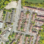
The age-old profession establishes the maps and boundaries for ownership and locations, the cadastre is a precise record of property boundaries, and records property ownership, entitlements and restriction. The Certificate of Title therefore provides the foundation for land valuation and transfer of property ownership.
This highly valued information is relied upon by the community and business. The cadastral boundary system supports title by supplying the physical definition of title boundaries (and other rights and interests) by licensed surveyors.
The ongoing accuracy of this information is critical. Incorrect data or use of such records would (and has) result in significant errors and disputes.
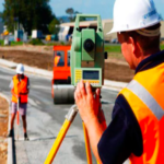
A few years back, surveyors used a surveyor’s chain and theodolite creating maps and plans. These plans would be lodged to the Titles office. Whilst the process of title registration is the same, rapidly changing technology and Google Maps have turned the industry on its head. These advancements allow surveyors to take measurements and report data with increased accuracy in a fraction of the time but have also made it far too easy for amateurs and unregistered surveyors.
The risk of not hiring a licensed professional surveyor is the equivalent of googling symptoms when you are sick, and people run the risk of building a house extension or installing drainage pipes that are incorrect, and not in line with the approved plan. This can be detrimental to future development and dramatically hinder the value of the land and even prevent the sale of the property.
In an industry threatened by technology, it is increasingly important for surveyors to stay relevant. Surveyors need to embrace new technologies and become industry leaders in how to use technology correctly whilst ensuring professional standards are maintained.
Licensed Surveyors continue to hold a critical place in the production of accurate and precise mapping information.
An organisation that is already embracing the changes within the surveying industry is the Queensland Spatial and Surveying Association (QSSA). An established place for Spatial and Surveying professionals in Queensland, the QSSA combines products and services like Queensland Globe and other applications with economic activity to be a national leader in furthering the spatial and surveying industry. The QSSA delivers quality service for members including:
- Advocacy for Queenslanders in the spatial sciences industries, by Queensland industry leaders
- Continuing professional development for surveyors
- Networking opportunities for industry professionals
- The sharing of information and keeping members up to date with industry affairs
- The nurturing of future leaders in the spatial industry
Being geodetic experts already, surveyors have the invaluable skills and critical analysis needed for any team trying to capture reality for the augmented world. So, it’s time to embrace the change, become experts in new technology and save the surveying industry.
Keiran Travers is the Managing Director of Harbak and the CEO of the Queensland Spatial and Surveying Association. QSSA provides its members with an opportunity to network face-to-face and online, as well as quality targeted education opportunities. For more information or to become a member, visit the QSSA website here or email [email protected].